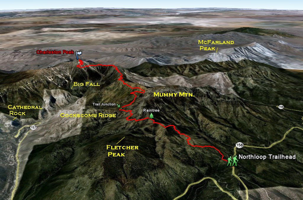


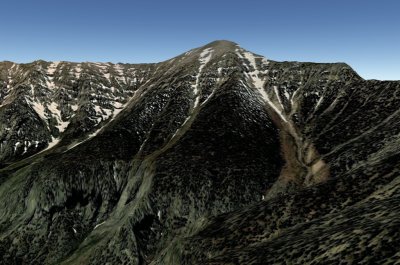
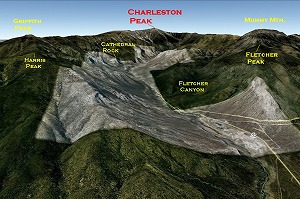
Charleston Peak
Location: Nevada, Spring Mtn. Range
Elevation : 11,918 ft
Overview...
Charleston Peak is the highest Peak in the Southern Nevada. Its located on the Spring Mtn. Range.
Route...
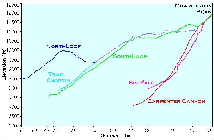
* From Trail Canyon *
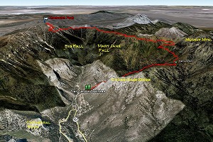
Trailhead is Trail Canyon Trailhead. (Upper or Lower)
Hike about 2 mile to get to the Trail Canyon/Northloop Trail Junction. Then follow the Northloop Trail for another 6 miles to the peak.
This is one of 2 most popular way to the peak. You can come down same way or take the Southloop trail down. In this case, you need to park another car at the Southloop trailhead for shuttle. Or you can hike another 1 mile back to Trail Canyon trailhead.
Stats:
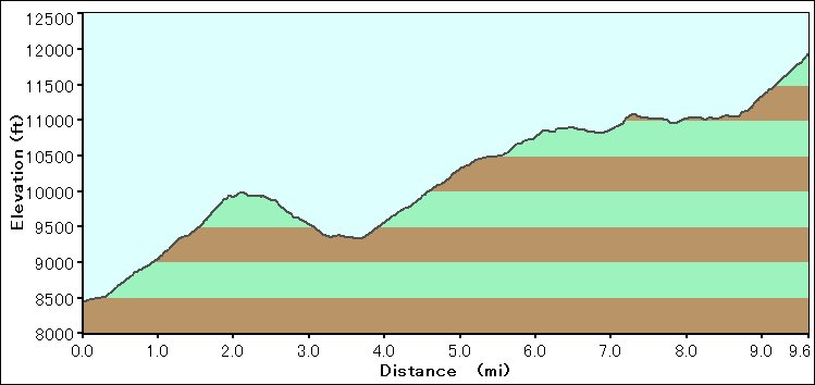
Distance: 8 miles (one way up)
Total Elevation gain: about 4,400 feet (to the peak) *1
Time: 8 - 10 hours (up and back)
Difficulty: 5
Class: 1
*1...if you take same way down, total elevation gain is about 4,600 ft
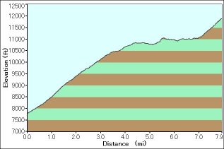
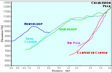
Elevation Chart
My hike Album....
2009/09/13
* From Southloop Trail *
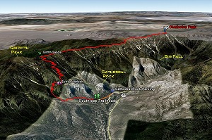
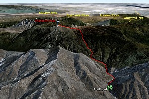
Trailhead is Southloop Trailhead.
Hike about 4 mile to get to the Griffith Saddle. From Junction, heading North West and follow the Southloop Trail for another 4 miles to the peak.
This is one of 2 most popular way to the peak. You can come down same way or take the Northloop/Trail Canyon trail down. In this case, you need to park another car at the Trail Canyon trailhead for shuttle. Or you can hike another 1 mile back to Southloop Trailhead.
Stats:
Distance: 8 miles (one way up)
Total Elevation gain: about 4,400 feet (to the peak) *2
Time: 8 - 10 hours (up and back)
Difficulty: 5
Class: 1
*2...if you take same way down, total elevation gain is about 4,600 ft
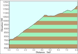
Elevation Chart
* From Northloop Trail *
Trailhead is Northloop Trailhead.
Hike all the 10 miles Northloop Trail to the peak.
This is little bit harder way to the peak. But, this is 100% trail hike.
Trail starts Northloop trailhead and goes up to high point (10,000 ft). Then slowly goes down. Pass the Raintree and down to the Trail Canyon/North Loop Trail Junction. Trail goes up again from the junction.
You can goes down Southloop or Trail Canyon if you park 2nd car at those trailhead for shuttle.
Stats:
Distance: 10 miles (one way up)
Total Elevation gain: about 4,400 feet (to the peak) *3
Time: 9 - 11 hours (up and back)
Difficulty: 5
Class: 1
*3...if you take same way down, total elevation gain is about 5,300 ft
Elevation Chart
My hike Album....
2008/06/29
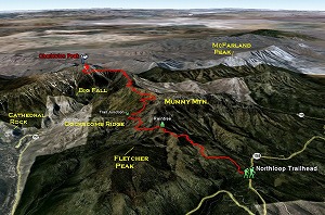
* From Big Fall *
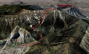
Trailhead is Mary Jane Trailhead.
Hike 1.3 miles to the Big Fall. From the Big Fall, scramble (class 3-4) up the left side wall for about 400 ft to the meadows. Cross the gully (top of the Big Fall) to the West, then scramble up again. The route goes up the ridge line then comes down to the gully to the West side. Follow the gully to the West for a little while. Then scramble up the scree slope on the right (West) side of the gully.
Once up on the ridge, cross the small gully to the West then scramble up the next ridge.
This is the ridge line basically goes up to the saddle. Airplane crash gully is on the right (North) side of this ridge. Try to follow the ridge near the Gully.
There are several dry falls at the lower part of the Airplane Crash Gully, but once gully get narrows, just follow the gully to the top. Its class 3-4 scramble. Last 200 ft to the Saddle is steep scree slope and there is a Airplane crash site at the saddle. From there, follow the Southloop Trail or Ridge line to the Charleston Peak.
If you are not experienced hiker, this is not a good way up to the Charleston Peak.
I recommend to descend Northloop-Trail Canyon Trail if you are not comfortable with class 4 descent.
Stats:
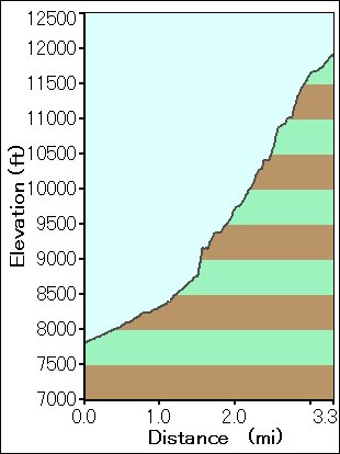
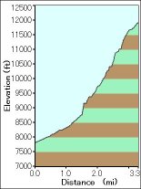
Distance: 3.5 miles (one way up)
Total Elevation gain: about 4,400 feet (to the peak)
Time: 4 - 5 hours (one way up)
Difficulty: 5
Class: 3 - 4
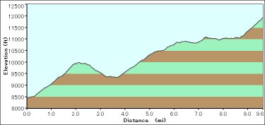
Elevation Chart
My hike Album....
2010/08/23
2009/08/01
* From Carpenter Canyon *
Trailhead is Carpenter Canyon. Carpenter Canyon is located on the South West side of Charleston Peak.
To get to the Trailhead, drive Bluediamond Road towards Pharamp. Pass the Charleston Blvd. junction and drive another 36 miles. (If you see the Gas station on your right, you came too far. Drive back 4 miles.)
There is a dart road on your right. This is the Carpenter Canyon Road. Drive all the way up for 12 miles.
Hike all the 10 miles Northloop Trail to the peak.
This is very hard way to the peak. There is NO clear trail until it gets to the South Loop trail.
From the trailhead, follow the creek towards upstream. There are so many faint pass on the both side of the creek. You need to cross the creek several times. (You wil not step in the water. but you have to jump across the rocks.)
Trail folks in 1.5 miles. One canyon goes towards East and another canyon goes towads North. Take the North (left one) canyon. Route gets steeper and there are few class 3-4 scrambles at dry falls.
Stats:
Distance: 10 miles (one way up)
Total Elevation gain: about 4,400 feet (to the peak) *3
Time: 9 - 11 hours (up and back)
Difficulty: 5
Class: 1
*3...if you take same way down, total elevation gain is about 5,300 ft
Elevation Chart
My hike Album....
2008/06/29
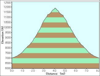
Elevation Chart Comparison
Related Link...